 English
 Spanish
 Portuguese
The Inca Trail to Machu Picchu
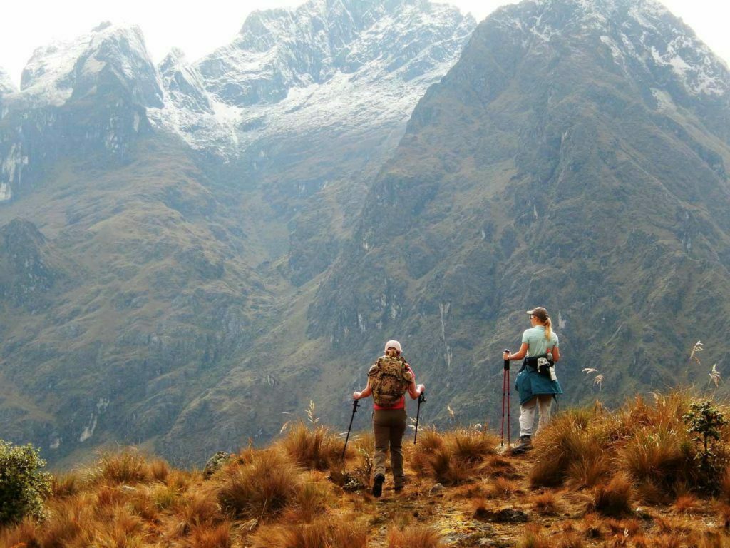
The Inca Trail to Machu Picchu is by far the most famous trek in South America and is ranked by many as one of the top 5 in the world. In just 43 km (26 miles) you can combine beautiful mountain scenery, lush cloud forest, subtropical rainforest and, of course, an impressive mix of cobblestones, ruins and Inca tunnels.

Machu Picchu 
Inca Trail 
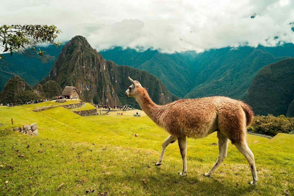
Llama in Machu Picchu
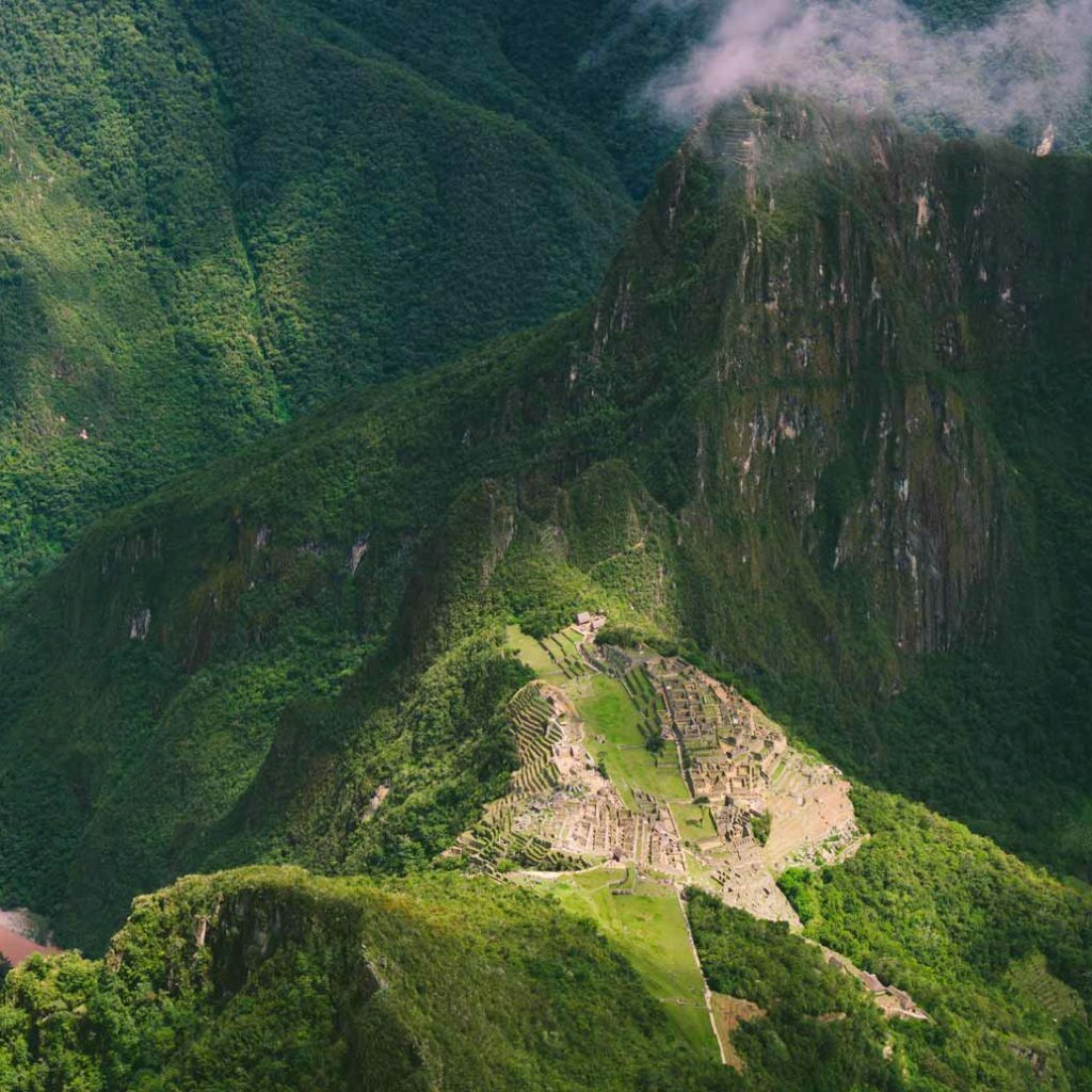
The final destination of the trail is unbeatable: Machu Picchu, the mysterious “Lost City of the Incas”.
The Inca Trail to Machu Picchu (also known as Inca Trail or Inka Trail) is a hiking trail in Peru that ends at Machu Picchu.
It consists of three superimposed trails: Mollepata, Classic and One Day.
Mollepata is the longest of the three routes with the highest mountain pass and crosses the Classic route before crossing Warmiwañusqa (“dead woman”).
Located in the Andes Mountains, the trail passes through various types of Andean environments, including cloud forest and alpine tundra.
Settlements, tunnels and many Inca ruins are located along the way before ending at Puerta del Sol on the Machu Picchu mountain.
The two longer routes require an ascent beyond 4,200 meters (13,800 feet) above sea level, which can result in altitude sickness.
Concern over excessive use leading to erosion has led the Peruvian government to put a limit on the number of people who can walk this trail per season, and to drastically limit the companies that can provide guides.
Advance booking is therefore mandatory. Each day a maximum of 500 people are allowed on the trail, of which only 200 are trekkers, the rest are guides and porters.
As a result, the high season (May, June, July and August) is booked very quickly.
The trail is closed every February for cleaning and maintenance by the Peruvian government.
Classic Inca Trail
Hikers normally take 4 or 5 days to complete the “Classic Inca Trail”, but a two-day hike from Km. 104 is also possible.
These routes start from one of the two points: 88 km (55 miles) or 82 km (51 miles) from Cusco on the Urubamba River at an altitude of approximately 2,800 meters (9,200 feet) or 2,600 meters (8,500 feet), respectively.
Both routes of the trail are on the Inca ruins of Patallaqta (sometimes called Llaqtapata), a site used for religious and ceremonial functions, crop production, and housing for soldiers from the nearby site at the top of Willkaraqay hill, an ancient pre-Inca site that first inhabited around 500 BC.
In the small town of Wayllapampa (“grassy plain”, Wayllabamba) the trail crosses the “Mollepata Trail” at 3,000 meters (9,800 feet).
Small permanent settlements are located next to the trail, and Wayllapampa has approximately 400 inhabitants (130 families) distributed along this part of the trail. Loading animals are allowed – horses, mules, donkeys and llamas.
At Wayllapampa the trail to Machu Picchu turns west and begins to ascend through a tributary of the Kusichaka. Due to previous hoof damage, no pack animals are allowed in the rest of the trail. For the same reason, metal-tipped trekking poles are not allowed on the trail or in Machu Picchu.
Ascent to Warmi Wañusqa
As the trail ascends to Warmi Wañusqa, or “Dead Woman’s Pass”, it passes through different habitats, one of which is a cloud forest with Polylepis trees.
The Llulluch’apampa (Llulluchapampa) campsite is on this stretch of trail at 3,800 metres. The pass itself is situated 4,215 m above sea level, and is the highest point of this trail, the “Classic Inca Trail”.
After crossing the pass, the trail drops abruptly into the Pakaymayu drain. At a distance of 2.1 km and 600 m below the pass is the Pakaymayu campsite.
The Runkuraqay Tambo
After passing Pakaymayu, the trail begins to climb steeply up the other side of the valley. One kilometer along the trail, at an elevation of 3,750 meters (12,300 feet) is the Inca Tampu Runkuraqay, ruins that dominate the valley. The site was largely restored in the late 1990s.
The trail continues to ascend, passing by a small lake called Quchapata (Cochapata) in an area that is recognized as a deer habitat. This site had been used as a campsite. As with other sites that were being degraded due to excessive use, camping is no longer permitted. The trail reaches the pass at an altitude of 3950 m.
The trail continues through the high, undulating, sometimes abrupt cloud forest, while offering increasingly dramatic views of the mountains and slopes. Then you reach the Sayaqmarka (“steep village”) followed by the tampu Qunchamarka. You pass a long Inca tunnel and a viewpoint overlooking two valleys: the Urubamba and the Aobamba (broken word).
Phuyupatamarka
Continuing with the route, this crosses another high point at 3650 m altitude, followed by a campsite, and after a short descent, a site with extensive ruins. The name Phuyupatamarka (“village at cloud level”) is given the same name for both the camp and the archaeological site.
Hiram Bingham III discovered the site, but left most of it covered with vegetation. The Fejos team named the site and discovered the rest. The design of the site closely follows the natural contours, and includes five fountains and an altar, which was probably used for the sacrifice of llamas.
The trail descends approximately 1000 meters including an irregular staircase of approximately 1500 steps, some of which were carved in solid granite. The vegetation becomes more dense, exuberant and “jungle” as with the increase of butterflies and birds.
Wiñaywayna and Inti Punku
The name Wiñay Wayna (always young) is used to refer both to a hostel, restaurant, campsite and to a set of Inca ruins. Two groups of large architectural structures, one lower and one upper, sit between multiple agricultural terraces on this concave site on the mountain slope. A long flight of fountains or ritual baths using up to 19 springs runs between the two groups of buildings.
From Wiñay Wayna the path undulates beneath the crest of the eastern slope of the mountain called Machu Picchu. The steep stairs leading to Inti Punku (“gateway to the sun”) are reached after about 3 km. Arriving at the crest of this place reveals the greatness of the ruins of Machu Picchu, which are below.
A short downhill walk is the last section of the trail.
Inca Trail Permits
Because of its popularity, the Peruvian government instituted several controls to reduce human impact on the trail and within the ancient city.
The most notable is a quota system, introduced in 2001, whereby only a certain number of people (including hikers, porters and guides) could walk along the Inca Trail each day.
This system is still in place; anyone wishing to walk the Inca Trail must obtain a permit beforehand.
As of 2016, 500 permits are issued per day. All permits for the year are issued in January and sold on a first-come, first-served basis.
Permits run out quickly, especially during the high season, which is especially the months of May, June, July and August.
Most operators advise hikers to purchase permits as soon as possible after release.
The government also ordered that each hiker on the trail must be accompanied by a guide. Because of this rule, permits can only be obtained through a government-registered tour operator.
All permits are accompanied by an individual passport and are not transferable. The government closely monitors the trail; there are several checkpoints along the trail.
Elevation of the Inca Trail
The elevation of the Inca Trail varies significantly and people often struggle with altitude sickness, especially if they have not spent much time in Cusco before walking the trail.
We have a complete section on this: The easy way to acclimatize to the height of Machu Picchu.
Cusco is located at 3,200 meters and is already significantly higher than Machu Picchu itself, however, many sections of the Inca Trail are much higher.
From 2,600 meters, the trail ascends to 3,300 meters on the first day.
The second day ascends over the Paso de la Mujer Muerta, the highest point of the Inca Trail at 4,200 meters. This is the most dangerous point in terms of altitude sickness, however, little time is spent at this elevation and the trail descends again to 3,600 meters.
The trail only descends from this point to Machu Picchu at 2,430 meters.
Accommodation in the Inca Trail
There are no lodgings along the route of the Inca Trail, all hikers camp.
Along the way, there are tents fully prepared for you before your arrival. You will sleep on comfortable camping mattresses, and only the best tents are used. You will stay dry and out of the elements, preparing for a great night’s sleep.
Food on the Inca Trail
As the Inca Trail cannot be done by you alone, the company you hire will take care of the food along the route.
Inca Trail Faqs
Start: Your journey to Machu Picchu will start in Peru’s city of Cusco.
Finish: You’ll complete your hike on the 4th day as you arrive at Machu Picchu’s Sun Gate in time to watch the sun rise over the misty citadel.
Most people say it is necessary to be in relatively good physical condition to walk the Inca Trail. It is not that the walk itself is extremely difficult (although technically it is more difficult than the Lares Inca Trail), but rather it is about making sure to take the best precautions to prepare for the altitude.
At its highest point the Classic Inca Trail ascends to 4,226 meters (13,866 feet) which is high enough for most people to be affected by altitude sickness and/or lack of energy due to low oxygen levels.
In terms of climate, the most popular time to walk the Classic Inca Trail to Machu Picchu is during the dry season that runs from May to October, when the rains in the Amazon basin are at their lowest point and you will be able to take full advantage of Peru’s blue sky days.
That said, April and November are also good options, as you tend to get the best of both worlds when it comes to the weather and there are fewer tourists around – which is always a good thing if you ask us!
The Classic Inca Trail is closed each year for the month of February. The wet season is at its peak between January and March, so with fewer hikers about it’s a great time to keep the trail in world class condition. During these months, you can still hike the other alternative treks on your journey to Machu Picchu.
Peru’s Ministry of Culture sets a daily limit for only 500 hikers per day on the trail – composed of 200 hikers and 300 guides/keepers. Part of the restriction stipulated that no one can walk the trail without the company of a guide, and each hiker requires a walking permit.
These restrictions are to maintain and take care of the Inca Trail in the best way.
If you are joining a guided tour, your operator will simply ask you for your passport details and they will organise your excursion permit. Be sure to plan your trip well in advance – permits to walk the Classic Inca Trail to Machu Picchu may run out 3 to 6 months in advance.
You can do other alternatives treks like Salkantay Trek, Lares Trek or Inca Jungle Trek.
Prepare for your hike to Machu Picchu before arriving in Peru.
The guided tours of the Inca Trail are designed for real people, both beginners in the world of hiking and experienced adventurers. Your guides will adapt your trip to your ability, allowing you to set the pace, regardless of which end of the spectrum you are at.
Inca Trail permits for every year go on sale on October.
Daily restriction of 500 hikers per day on the trail – made up of 200 hikers and 300 guides/porters.
There are showers and toilets in the camps along the Inca Trail. But the water is colder than the Atlantic, and the toilets are a challenge.
If you are strong and brave you can bathe in cold water.
Bring plenty of wet wipes, lots and lots of wet wipes! A good cleaning before going to bed is very advisable.